

The Ohio to Erie Trail (www.ohiotoerietrail.org) is not a trail, per se, but a collection of trails and on-road routes that provide a bicycle touring route that connects the three "big C's" of Ohio (Cincinnati, Columbus, and Cleveland). About 80% of the 350-mile route is on dedicated bike paths, with the rest on public roads.
I wouldn't be camping during my trip, so I was able to pack pretty light; just a couple days' worth of clothing and the usual tools and spare parts. You can read the details about what I packed in this post on my personal bike blog:
Gear List: Credit-card Bikepacking the Ohio to Erie Trail
My trip began the morning of Sunday, September 27 when my brother arrived in his mini-van to haul my bike and myself down to Cincinnati. I made a few adjustments to my bike and what I packed that morning, based on the weaterh forecast as well as some bike issues.
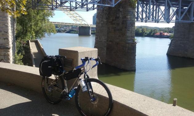
My brother and I stopped for lunch outside Columbus, then he dropped me off at BioWheels bike shop in Cincinnati. BioWheels is where Austin (who used to work with us in Peninsula) now spends his working weekends, and he agreed to let me crash at his place for the night.
 |
| With my lightly loaded Salsa Fargo bike at BioWheels in Cincinnati |
Ohio to Erie Trail Tour: Prologue
Day 1: Monday, September 28, 2015
Austin actually lives in the small village of North Bend, almost 20 miles down-river from downtown Cincinnati. The main road connecting North Bend with Cincinnati is busy 4-lane US Route 50. I had about a 2-mile stretch on this road before I detoured on some quiet back roads, then another 2-mile stretch just before I reached the city.
I stopped in town for some breakfast, then found Yeatman's Cove Park, the official start of the Ohio to Erie Trail on the shores of the Ohio River.
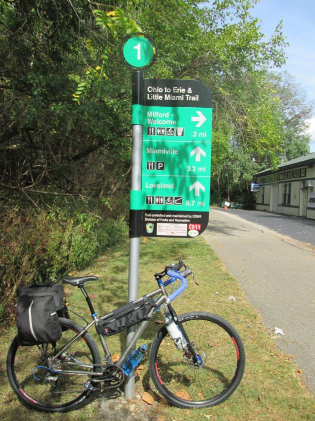
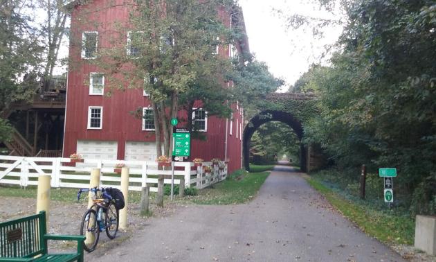
Finally, I got to the Little Miami Scenic Trail, a paved rail-trail that makes up a large part of the Ohio to Erie Trail's southern end. I hopped on the trail a few miles south of the town of Milford. At Milford, I looked around town a bit (including the local bike shop and a new outdoor store), then continued on my way.
My day ended in the town of Waynesville, and was my only paid night's stay for the week, at the Creekwood Motel on the edge of town. There are a few local restaurants to pick from in Waynesville, plus a plethora of antique shops. Mileage for the day was almost 81; more details of the day at:
Ohio to Erie Trail Tour: Day 1 – North Bend to Cincinnati to Waynesville
Day 2 - Tuesday, September 29, 2015
I got some breakfast at the local diner in Waynesville, and continued on the trail. There was a light rain falling as I got started. The Little Miami Scenic Trail goes all the way to Xenia, the hub of southwest Ohio's bicycle network, where five trails all meet at the Xenia Station.

In South Charleston, I came across another group on a bike tour.

They were doing a supported loop around southwest Ohio to raise money to build an orphanage in Ukraine. You can read about their organization here: endscycling.com
The rain continued and got a little worse as the day went on. I got some lunch in London, and as you make your way through this town, the route continues on the Roberts Pass Trail, which later becomes the Camp Chase Trail.
 |
| On the Camp Chase Trail - a reminder of the journey still ahead of me |
Mileage for the day was 68; more details at:
Ohio to Erie Trail Tour: Day 2 – Waynesville to Lockbourne
Day 3 - Wednesday, September 30, 2015
I made my way back to the Ohio to Erie Trail starting with an easy 10 miles on some local roads that weren't nearly as busy as the final miles the day before. Then, I got on the Alum Creek Trail, which winds it way up the east side of Columbus. In Westerville, I re-joined the Ohio to Erie Trail Route, which continues on the Westerville Bikeway.

I stopped in Centerburg, very hungry, wishing I had stopped for lunch back in Westerville. I grabbed a quick lunch at the local Subway, then got on the Heart of Ohio Trail just a couple blocks from downtown.


This picturesque bridge marks the village of Howard, my destination for the day.

Ohio to Erie Trail Tour: Day 3 – Lockbourne to Howard
Day 4 - Thursday, October 1, 2015
It was back on the Kokosing Gap Trail from Howard to Danville. Cutting through a few local streets in Danville, the Ohio to Erie Trail route continues on the Mohican Valley Trail.


Route 62 is busy, narrow, and has a lot of truck traffic and some rolling hills. Fortunately, it only lasts about 3 mile before the route detours onto some smaller back roads. This area is beautiful Amish farm country, but it also means steeper hills. This day, it also meant more headwinds. I pushed on through until the town of Killbuck, where the route gets back to bike trail, the Holmes County Trail.


Mileage for the day was almost 79. I got some dinner in town, and of course, no visit to Canal Fulton is complete without a stop at the Cherry Street Creamery for dessert.
Day 4 details:
Ohio to Erie Trail Tour: Day 4 – Howard to Canal Fulton
Day 5 - Friday, October 2, 2015
After pancakes in Canal Fulton, it was back on the Towpath, and I was joined by Ray, one of my hosts.


 |
| The Beaver Marsh in the Cuyahoga Valley National Park |

The wind was worse than ever today, and got worse and worse the closer I got to Lake Erie. Reaching the end of the Towpath, I made my way through Tremont and Ohio City, stopping on Abbey Avenue for my best view of downtown Cleveland.

I rode west on Lorain Avenue to W. 45th Street, then west on Detroit Road to W. 65th Street, taking the tunnel connection to Edgewater Park. I asked a kind stranger to get a photo of my official finish.

The wind was howling, going straight from east to west. There were surfers on the lake, something that's only possible a handful of days out of the year. Go to my final complete report to see a video of the windy shoreline:
Ohio to Erie Trail Tour: Day 5 – Canal Fulton to Cleveland
If you're a novice to bicycle touring, I'd recommend the Ohio to Erie Trail as a good beginner-friendly trip to see how you like it. You don't have to camp, and you don't have to ride the whole route; you can pick two or three days. The route is mostly easy to follow, and there are plenty of easy-to-find options for food and lodging along the way.
I had a very enjoyable trip. Thanks to everyone who helped me along the way!
Go to www.ohiotoeerietrail.org for more details, including links to order your own maps!
Thank you for writing this, Kevin. My wife and I are heading up in September 2019, and we are looking forward to seeing the sites you have mapped out. Keep safe!
ReplyDelete